

Innovations in 3D Laser Scanning: Revolution in Engineering
In the fast-paced world of engineering, innovation is key. Among the most groundbreaking advancements is 3D laser scanning. This technology is...
4 min read
In the world of engineering and construction, precision is paramount. Every measurement, every angle, and every detail can make the difference between success and setback. For years, professionals in these fields have relied on traditional methods of surveying and documentation to understand and manipulate physical spaces. But as technology advances, so too does our ability to capture, analyze, and leverage data in ways previously unimaginable.
Enter the world of 3D Facility Scans, a pioneering leap in technology, offering an innovative solution that is revolutionizing the industry.

Facility scanning, also known as 3D scanning, revolutionizes the way engineering firms assess and analyze physical spaces. Unlike traditional methods that rely on manual measurements and blueprints, facility scans utilize cutting-edge technology to capture detailed three-dimensional data of buildings, structures, and landscapes. Here's how it works:
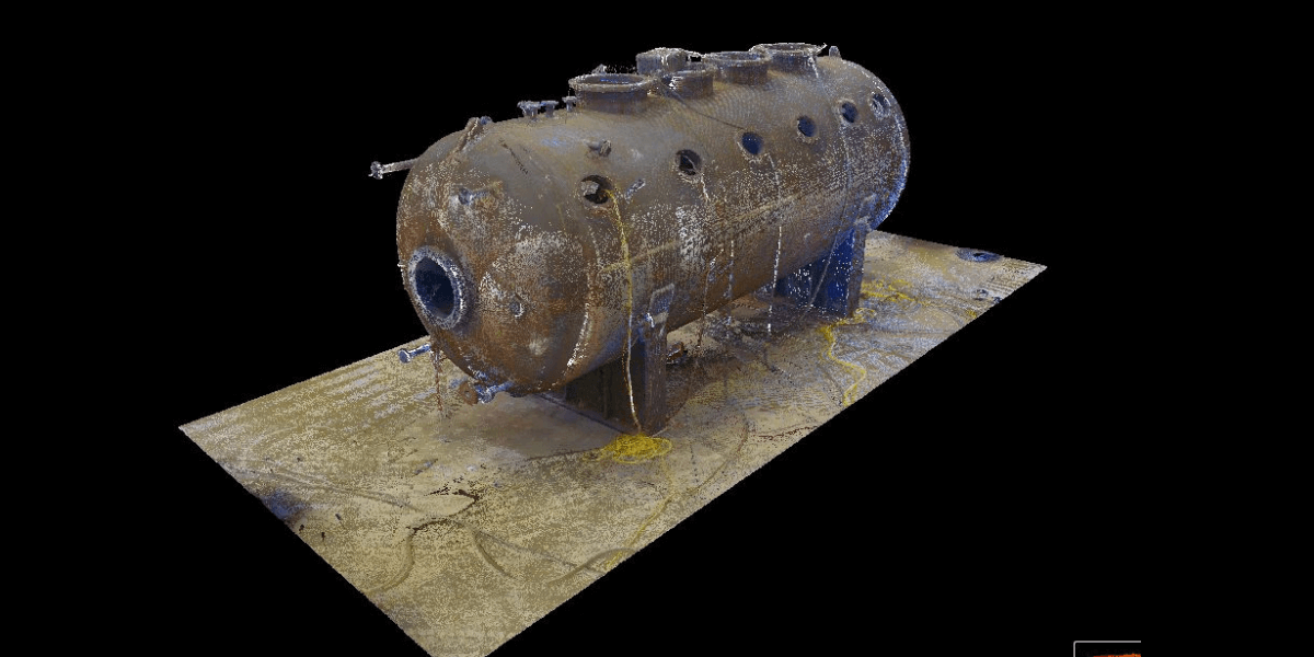
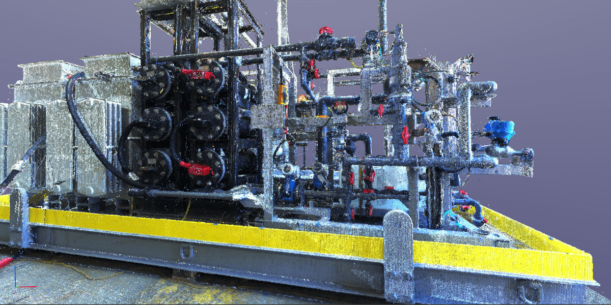
Laser scanning, often based on LiDAR (Light Detection and Ranging), emits laser beams that bounce off surfaces and return to the scanner. By measuring the time it takes for the laser to return, the scanner creates precise distance measurements. These measurements form a point cloud, a collection of millions of data points representing the geometry of the scanned area.
Structured light scanning projects a pattern of light onto the surface being scanned. As the pattern deforms over the contours of the object, cameras capture images of the distortion. By analyzing how the pattern distorts, the scanner can generate a 3D model of the object's surface.
Photogrammetry involves taking multiple overlapping photographs of an object or space from different angles. Software then analyzes these images to calculate the spatial relationships between points, creating a detailed 3D model.
ToF scanning measures the time it takes for light or laser pulses to travel from the scanner to the object and back. By calculating this time, the scanner determines the distance to each point on the object's surface, creating a 3D representation.
Facility scans offer a myriad of benefits to engineering firms and facility managers:
By capturing millions of data points, facility scans provide incredibly accurate representations of physical spaces, minimizing the margin for error in design and construction processes.
Compared to traditional surveying methods, facility scanning significantly reduces the time and resources required to capture and analyze data. This efficiency translates to cost savings and faster project completion times.
Facility scans create detailed documentation of existing conditions, allowing engineers and architects to make informed decisions throughout the design, renovation, or maintenance process.
With digital models and point cloud data readily available, stakeholders can remotely access and collaborate on projects without the need for site visits, streamlining communication and decision-making.
By rendering existing environments, this allows designers, engineers, and manufacturers the ability to place renderings of new equipment in rendered existing facilities, which provides the ability to uncover many misinterpretations beforehand.
Plant Managers gain the ability to visualize the impact of new equipment in the facility, Operations Managers and Supervisors have the ability to weigh in on operational aspects of consideration, and CEO’s and CFO’s get to see what they’re purchasing installed in their facility before writing the check!
By carefully documenting the specific features of a building's design and structure, 3D laser scanning can identify and address possible safety concerns, ultimately creating a safe and secure environment.
3D facility scanning provides a fast and effective method for visualizing different equipment arrangements in a 3D setting, helping to identify and resolve any installation conflicts early on in the planning stage. Additionally, it enables the preview of potential equipment placements within the facility, thereby improving the planning and decision-making processes.
Utilizing advanced 3D laser technology allows for the accurate recording of an object's form, texture, and color details. This process enables the creation of detailed digital copies that can be used for immediate monitoring and examination purposes.
At the heart of facility scanning technology lies the point cloud – a dense collection of 3D points representing the surface of scanned objects or environments. Point clouds serve as the foundation for various applications, including:
Point clouds serve as the basis for creating detailed CAD (Computer-Aided Design) models, enabling engineers and architects to visualize and manipulate scanned spaces with precision.

Point clouds can be integrated into VR and AR environments, creating a seamless bridge between the physical and digital worlds. Through virtual and augmented reality technologies, users can not only explore but also interact with the scanned spaces in ways that were previously unimaginable.
Imagine walking through a building that exists only in the digital realm, being able to manipulate its structure, change its layout, and experiment with different design options, all in real-time. This level of immersion and interactivity opens up endless possibilities for architects, engineers, and facility managers to visualize and optimize their projects with unparalleled precision and creativity.
By overlaying point cloud data onto CAD models, facility managers can not only identify maintenance issues, plan renovations, and optimize space utilization with ease, but they can also streamline facility management processes and enhance overall operational efficiency. This integration allows for a comprehensive overview of the entire facility, enabling managers to visualize and analyze every aspect of the space in intricate detail.
By utilizing advanced software tools, they can utilize geotagging thereby accessing equipment manuals more efficiently, plan maintenance schedules, and even simulate different layout configurations to maximize functionality and productivity.
Facility scanning technology continues to redefine the way we perceive and interact with physical spaces. From laser scanning to photogrammetry, each method offers unique advantages in capturing accurate, detailed data for engineering and facility management applications.
At Blue Collar LLC, we embrace these innovations, as we stand at the forefront of efficiency and precision in the 3D scanning environment. Learn how Blue Collar can help you by clicking below!

At Blue Collar Engineering, we specialize in turning concepts into reality. With expertise in 3D scanning, design and drafting, prototyping, engineering, and production management, our team is dedicated to bringing your ideas to life with precision and passion.
From initial concept to final product, we are committed to delivering innovative solutions that meet and exceed your expectations. Whether you're in the Food & Beverage, Oil & Gas, or Outdoor Industries, our multidisciplinary team is equipped to provide turnkey solutions tailored to your needs.
In the fast-paced world of engineering, innovation is key. Among the most groundbreaking advancements is 3D laser scanning. This technology is...
When it comes to engineering, precision and efficiency reign supreme. To achieve these goals, engineers are increasingly more often turning to...

Efficiency and safety are key drivers of success in today’s competitive business environment. An optimal equipment layout is one of the most critical...